

The more I learn about the Ohio River’s regional history and culture, the more I feel like I’m taking a Virginia history class. You’ll see why when you take this month’s trivia quiz! If you want a leg up, check out this prior newsletter concerning Virginia’s land claims.

Note to my fabulous new subscribers:
It’s the rare person who can answer all ten trivia questions without any prep. I couldn’t answer them without a significant amount of research, either! Do your best and enjoy learning something new. Answers in the footnotes.
QUESTIONS
All answers are in the footnotes.
The first two questions refer to this map.

How did this huge swath of land (above in green) come to be named Virginia? Check all that apply.1
When Sir Walter Raleigh’s self-funded settlement on Roanoke Island failed, he needed to curry favor with Elizabeth (the Virgin Queen) to finance another attempt. Part of his pitch was that the new country would be called “Virginia.”
One word: hubris.
Four words: The Doctrine of Discovery.
In what order was Virginia subdivided into colonies? I have alphabetized the answers, so put them in order.2
Colony of Carolina.
Colony of Maryland.
Colony of Pennsylvania.
Colony of Plymouth (Plymouth Colony).
Refer to the map below. Virginia was still a huge state in 1783, even after it had been subdivided into the colonies in Q2. Which Virginia founding father, himself trained as a surveyor, authored a plan for ceding Virginia’s northwestern lands to the Confederation Congress in 1784?3

Let’s talk about the Virginia Military District in Ohio. In return for ceding its land claims to the Confederation Congress in 1784, Congress granted Virginia roughly 4.2 million acres to provide military bounty land grants as payment (in lieu of cash) for its veterans of the American Revolutionary War. When was the remaining land no longer eligible to be granted to these Virginia veterans? Only one of these is correct:4
When the Northwest Territory was established in 1787.
When Ohio became a state in 1803.
On February 18, 1871, when any unsurveyed and unsold District land was ceded to the state of Ohio.
In 1872, when the Ohio legislature gave this land to the Ohio Agricultural and Mechanical College (now The Ohio State University).
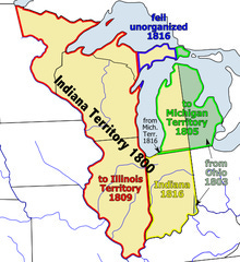
The Northwest Territory was established in 1787 by the Confederation Congress. When did the Territory cease to exist?5
When Ohio became a state in 1803.
When the Indiana Territory was finally settled into the states of Indiana, Michigan, Wisconsin, Minnesota, and Illinois (1809).
The Northwest Ordinance that established the Territory specifically prohibited slavery. I wrote about that here. Which of these is true of the history of slavery in this region? More than one may apply.6
Slavery was introduced to Illinois in 1719 by Philip Francois Renault who brought 500 slaves with him from San Domingo via the Mississippi River.
While the Northwest Ordinance prohibited slavery, this did not apply to any slaves already in the Territory when it was established (1787).
Enslavers continued the practice by using contracts of indenture that allowed indentured workers to be bought, sold, and inherited.
What is the importance of the Southwest Territory? Choose as many as apply.7
It’s formal name is the Territory South of the River Ohio, and was created from lands of the Washington District that had been ceded to the U.S. federal government by North Carolina (which had once been Virginia).
The new territory was essentially governed under the same provisions as the Northwest Ordinance, but the Article outlawing slavery was not applied to the Southwest Territory.
Kentucky and Tennessee were carved out of this Territory.
Virginia produced a lot of presidents and governors. Which Virginia-born governors in the six Ohio River states were slaveholders? More than one choice may apply.8
Ohio Governors Thomas Worthington and Allen Trimble
Indiana Governors William Henry Harrison and Thomas Posey
Illinois Governor Edward Coles
Kentucky Governors George Madison and Christopher Greenup
In a departure from the “Virginia Method” of surveying land, The Northwest Territory used the Rectangular Survey System (RSS). This system can be thought of as a grid that covers the U.S. What was the difference between it and the Virginia Method? More than one may be correct:9
The Virginia Method used chains and compasses to mark lines from a starting point, typically a natural feature such as a large white oak tree.
Surveying in Virginia was not based on the metric system.
Virginian surveyors were directed to define polygons that enclosed high-quality land for farming and to exclude areas with poor soil.
Beginning with the Seven Ranges in present-day Ohio, the Rectangular Survey System has been used as the primary survey method in the United States. Which states do NOT use this method exclusively?10
Ohio
California
Washington, Oregon, Idaho, and Wyoming
Wisconsin

And that’s a wrap for May. Do you have an interesting factoid to offer about Virginia’s role in the 981 Project? I’m all ears.
ANSWERS
The correct answer is all but a. I wrote the first answer to trick you, but it’s ALMOST true. Sir Walter Raleigh did name the land Virginia, but he didn’t get a second chance at colonizing when Roanoke Island failed because Elizabeth didn’t back him. Source.
If you don’t think hubris was a factor, that’s fine. You’re keeping your own score.
The Doctrine of Discovery was invented by Papal Bull “Inter Caetera,”that gave license to explorers to claim “vacant land” (defined as not populated by Christians) in the name of the sovereign. Source. I’m not sure Sir Walter Raleigh had any choice but to name Virginia for the sovereign, in accordance with this Doctrine. If you know, please tell me!
Plymouth, 1620
Maryland, 1632
Carolina, 1663
Pennsylvania, 1681
Thomas Jefferson.
The only correct answer is b, when Ohio became a state in 1803. All the other answers are things that happened in the former Virginia Military District, but had no bearing on when the land grants ended.
Virginia soldiers of the Continental line, who served in the Revolutionary War, were granted land according to a formula based on rank and time of service. Source.
The only answer is a. Once Ohio became a state, the rest of the Territory became the Indiana Territory. When Indiana became a state in 1809, The Illinois Territory was established.
All are true. Remember, most of the land in the Northwest Territory had once been controlled by the French. In 1628, the first “negro” slave was brought to Quebec by the English, and in 1685, the Code Noir authorized slavery in the French colonies. Virginia’s ownership of the territory was equally important on this question. Here’s the source for answer options I offered.
Kentucky was not part of the Southwest Territory, but Tennessee was. Therefore, the answer is a and b.
Only the Indiana governors held slaves. Southern immigrants who were anti-slavery settled in Ohio, where a strong anti-slavery movement was underway. The immigrants in favor of slavery generally moved to Indiana, where the government was friendly to slaveholders. William Henry Harrison, whose Grouseland mansion I recently visited in Vincennes, likely built it with slaves he brought with him to the Indiana Territory before the Northwest Ordinance was enacted. He asked Congress to suspend the anti-slavery clause of the Northwest Ordinance for ten years, claiming it was necessary to increase the territory's population more quickly and attract new settlers. Source.
Thomas Posey was publicly anti-slavery, yet, he left enslaved people to his children in his will. Classic move. Source.
All are true, and I wouldn’t have guessed Ohio didn’t use the system exclusively. Ohio's Virginia Military District was surveyed using the metes and bounds system that Virginia had always used. Areas in northern Ohio (the Connecticut Western Reserve and United States Military District) were surveyed with another standard, sometimes referred to as Congressional Survey townships, which are five miles on each side instead of the six miles standard implemented by the RSS/PLSS.
California, before statehood in 1850, used the boundaries of Spanish and Mexican land grants (ranchos); since statehood the PLSS was used to convey government lands.
Parts of Washington, Oregon, Idaho and Wyoming were settled as Donation Land Claims.
Wisconsin had French settlement prior to the RSS/PLSS in the areas of Green Bay and Prairie du Chien. Both areas were initially divided using the French Long Lot system along the water frontage.