When people hear the word “reparations” today, it’s usually in a context of compensating African-Americans or Indians for damages they suffered, including forced and unpaid work, or for theft of their land and livelihoods among other harms. As a reminder, Japanese-Americans received reparations after they were deprived of their liberty (internment) and for property that was confiscated from them during WWII.
Today, we broaden that lens and look at the instances when Ohio was carved up as a form of reparations to Revolutionary War veterans and other classes of people who Congress wanted to “restore to good condition,” before Ohio became a state.
Before we go to this month’s trivia, let’s get clear on the definition of the word reparation(s). I lifted this directly from Dictionary.com
Reparation: noun
the making of amends for wrong or injury done:
In reparation for the injustice, the king made him head of the agricultural department.
something done or given to make amends:
The prosecutor has requested a reparation of $32 million to victims of the crime.
Synonyms: compensation, satisfaction, atonement, indemnification
Usually reparations.
compensation in money, material, labor, etc., payable by a defeated country to another country or to an individual for loss suffered during or as a result of war:
The U.S. government eventually disbursed reparations to Japanese Americans who had been interned during World War II.
monetary or other compensation payable by a country to an individual for a historical wrong:
The article is about reparations to Black people for the enslavement of their ancestors.
restoration to good condition.
REMINDER: It’s the rare person who can answer all ten trivia questions without any prep. I couldn’t answer them without a significant amount of research, either!
Do your best and enjoy learning something new. Answers in the footnotes.
QUESTIONS
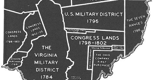
All questions refer to this district map. For this quiz, try thinking of Ohio as a clock face. The districts in question start at the 12:00 position with the district labeled “The Fire Lands 1792.” We’ll move clockwise from there.
All answers are in the footnotes.

Moving to the 1:00 position on the map, we find The Connecticut Western Reserve 1786. When King Charles II granted Connecticut’s 1662 Charter, he defined it broadly and ambiguously. Settlers in the newly-chartered colony seized upon the ambiguities to make the largest claims possible, which stretched from the East Coast through Ohio all the way to the Pacific (which is also what Virginia did earlier). They refused to concede this little patch in The Ohio Country after a series of concessions to other colonies and countries for their western lands until forced to do so by Congress in 1786. Which of the following is true about the Connecticut Western Reserve?1 More than one may apply.
Connecticut yielded claims to the region to Congress in 1786 so that Congress could establish the Northwest Territory.
Connecticut drove a hard bargain when yielding its claims in 1786. When the Continental Congress created the Northwest Territory the year after the Connecticut cession, it was assumed that Connecticut, not the territory, was empowered to exercise political jurisdiction over the Reserve. The ambiguity lasted until the Constitutional Congress approved the "Quieting Act" in 1800, whereby Connecticut surrendered all governing authority.
The Fire Lands (at 12:00) were carved out of the Connecticut Western Reserve in 1792, and the rest was sold to the Connecticut Land Company in 1795 to fund public education. If this is true, the only lands from the Connecticut Western Reserve that were given in reparation were The Fire Lands.
How did the Fire Lands 1792 district get its name? More than one may apply.2
It’s the shortened version of Fire Suffers’ Lands.
It was set aside for anyone who owned Connecticut property that had been burned by the British during the Revolutionary War.
Working for the British, Benedict Arnold raided and burned 140-plus buildings in New London, Connecticut, along with ships docked in the port. Those who suffered in this attack were eligible for land in Ohio as reparation.
The Seven Ranges (at about 3:00), is sometimes referred to as the Old Seven Ranges, and was established the same year as the Connecticut Western Reserve (1786). The Continental Congress needed a survey system for a systematic expansion into Ohio, so the Seven Ranges was a demonstration project of sorts. The ranges were surveyed in what became the Public Land Survey System, still in use today (discussed in May ‘24 Trivia). After the survey was complete, the Secretary of War was to choose (by lot) one seventh of the land to compensate veterans of the Continental army. The rest of the lots were to be sold at auction in New York. Which of these lands were excepted from the New York auction? More than one may apply.3
A wealthy merchant, Arnold Henry Dohrman, aided the Revolutionary War effort at great expense while living in Portugal. Unable to fully compensate him monetarily, Congress granted him township 13 of range 7.
After the Revolutionary War, Capt. Ephraim Kimberly, (Company of the 2nd Connecticut) squatted on some of the lands. Congress eventually granted Kimberly 300 acres for his services.
Four sections in every township were reserved for future sale by the federal government in hopes they would bring higher prices because of developed land around them. So if this answer is correct, the federal government did land speculating there.
You’ll have to squint to see this rectangular parcel on the Ohio River between The Seven Ranges at 3:00 and The Ohio Company First Purchase at about 5:00. It’s called the Donation Tract and consists of only 100,000 acres. It was created after the Big Bottom Massacre of 1791 as a buffer zone that would shelter Ohio Company lands from further Indian incursions. To this end, a 100-acre lot would be given to any male, eighteen or older, who would settle on the land at the time the deed was conveyed (no land speculating here). More than one of the following is true about the Donation Tract.4
In 1818, lands not conveyed reverted to the federal government and were sold at the Marietta Land Office.
This marked the first time that federal land was given without charge to specified settlers, predating the more famous Homestead Act of 1862 by seventy years.
We can’t determine whether the land really served as an Indian buffer zone for the Ohio Company lands.
My favorite of all the “reparations lands” in Ohio is the Old Military District because I grew up there. Look for it west of the Seven Ranges (covered in Q3) and south of the Congress Lands of 1799-1804. Contrary to what the name implies, many veterans did not settle there. Instead, they used their warrants to speculate. Which of the options listed below were located in the Old Military District and not available to Revolutionary War veterans?5 More than one may apply.
Moravian Indian Grants.
The villages of Schoenbrunn, Gnaddenhutten, and Salem, which were granted for the sole use of the Christian Indians.
Land to build a road, between Wheeling to what’s today called Maysville, Kentucky. This road became known as Zane’s Trace, and Ebenezer Zane got the concession to establish ferries along the road to cross the Muskingum, Hocking, and Scioto rivers, along with several other land grants in the District.
Starting at the southern border of Ohio at about 7:00, we have the sprawling Virginia Military District (1784). Why is it such an irregular shape, as compared to the others in the state?6
It is not surveyed into townships of any regular form. Any individual holding a Virginia military land warrant took land in whatever shape he pleased, provided no one else had claimed it.
It was surveyed using the old English system of “metes and bounds.”
Since it was established before all the other Districts (1784), the others had to be surveyed around it.
Squint your eyes for a little rectangle of land east of the Virginia Military District (1784) and south of the U.S. Military District (1796). It is called the Refugee Tract. How did Canadians and Nova Scotians qualify for land in this District?7
Look closely at the map around 8:00 to see the Symmes Purchase, named for Judge John Cleves Symmes of New Jersey in 1788 from the Continental Congress. It was one of the first areas settled in Ohio. What’s true about this area? More than one of these four may apply.8
Known as the Miami Country, it sits between the Great and Little Miami rivers.
Symmes' men committed many errors while performing the survey, including using magnetic north rather than correcting for true north.
Symmes sold land that he did not own, some as far north as Dayton, meaning that some early settlers found themselves squatters on the public domain.
Not only did Symmes sell some land that he didn’t own, but he did it more than once.
Squint your eyes again as you find a tiny rectangle at about 6:00 within the Congress Lands 1798-1802. This is known as the French Grant because it was settled by French fleeing the Revolution in their home country. Why were French entitled to American land?9
They were descendants of French families who had aided the American Revolution, including the extended family of America’s favorite Frenchman, Lafayette (Marie-Joseph Paul Yves Roch Gilbert du Motier de La Fayette, Marquis de La Fayette).
They had been defrauded by The Scioto Company which had collected some monies from the French without purchasing the land from the Ohio Company. When the settlers arrived their deeds were worthless. It was five more years before Pres. Washington stepped in and granted them free land in the French Grant, but they had to live on the land for five years in order to own it.
There was a dispute between Michigan and Ohio over who owned the land identified in the area labeled “Michigan Survey 1836.” When was it finally settled? Fun fact: Those 468 square miles are also called the “Toledo Strip.”10
During the War of 1812, but ground survey was not completed until 1817.
In 1836, when the Michigan Territory gave up the “Toledo Strip” and received the large majority of the Upper Peninsula and Michigan.
When Michigan became the 26th State on January 26, 1837.
When the 48th Legislature of Michigan passed Act 84 of the Public Acts of 1915 providing for “a joint re-location and permanent monumenting of the line between Ohio and Michigan”.
In 1915 when the 81st General Assembly of Ohio passed the Michigan Act of 1915 (in answer d) under House Bill 701.
Intermission
This month, here’s a podcast about Mad Anthony Wayne and the Battle of Fallen Timbers. Wayne National Forest in Athens County, Ohio, bears his name.
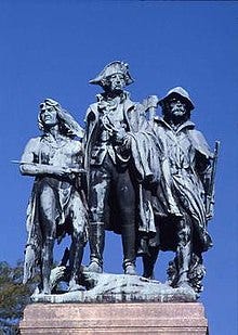
All are true, but b & c are the MOST TRUE. Here’s a concise analysis of Connecticut’s border claims and disputes. If you want the nitty-gritty details, here’s your page.
And yes, Case Western Reserve University is in this tract. Although the trustees of Case Institute of Technology and Western Reserve University did not formally federate their institutions until 1967, the institutions already shared buildings and staff for some time.
The only accurate answer is a. The problem with b. as written is that it’s too broadly defined (“anyone” in Connecticut). The problem with c. is that it’s too narrowly defiined. Eligibility was open to residents of Danbury, New Haven, Fairfield, Norwalk, and New London who had suffered fire damage. Simplicity is sometimes the best guess, as is the case here.
All three are true. The Seven Ranges terminus has a new marker near (now) Magnolia, Ohio 40°39′07″N 81°19′05″W.
All are true. As for c., the Ohio Company lands never experienced another Indian raid to compare with the Big Bottom Massacre of 1791, so there is no scientific way to say the Donation Lands played a role in that history.
All are correct, but I should clarify that Ebenezer Zane was a Revolutionary War veteran and for his work establishing the trace on time and in an acceptable manner, he received 640 acres of land at the confluence of the Muskingum and Licking rivers (Zanesville), and another 640 acres at a spot where the trace crossed the Hocking River, (Lancaster). He was also given 640 acres across the river from Chillicothe, the only area along the trail that had a settlement at the time.
As to the Christian Indian grants (a and b), few Indians chose to live in these areas. The lands eventually retroceded to Congress. The Moravian missionaries (answer a) received enough to repay their debts from improvements, and the Christian Indians received $400 per year.
Here’s a link to a Ph.D. thesis on the Moravians in Ohio. My best friend from kindergarten was a member of The Church of the Brethren, which is another name for the Moravians. I occasionally went to services with her, but we spent our time coloring. I recall the services were very quiet and that I didn’t recognize the hymns.
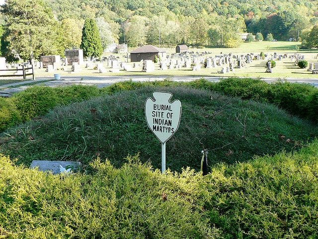
The story of the Gnadenhutten massacre needs to be told. During the American Revolutionary War, these pacifist Indian tribes (mostly Lenape and Mohican) found themselves between British-allied Indian tribes to their west and American settlers to their east. In 1782, American militiamen came to Gnadenhutten, rounded up the Indians and executed 96 men, women and children. The women were systematically raped before their deaths. As they were being killed, the Moravians sang "hymns and spoke words of encouragement and consolation one to another until they were all slain.” Source: Diary of David Zeisberger, a Moravian missionary among the Indians of Ohio. R. Clarke & Company. 1885. pp. 80–81, 83.
More than a century later, Theodore Roosevelt called the massacre "a stain on frontier character that the lapse of time cannot wash away." Source: Roosevelt, Theodore, The Winning of the West, Volume 2, p. 145. G.P. Putnam's Sons, 1889.
All are true. Metes and bounds are the boundaries of a parcel of real estate that is identified by its natural landmarks. They are often used in a “legal description” of a land. In legal descriptions, metes and bounds are considered as the most accurate description of a piece of land in some jurisdictions. Source.
“More than double the litigation has probably arisen between the holders of adverse titles, in this district, than in any other part of the State.” Source.
Canadian and Nova Scotian sympathizers with the American cause who rendered aid, including joining the American Army, saw their possessions confiscated by the British Crown. In 1798, Congress published advertisements in newspapers inviting those with claims to file an account within two years. The Secretaries of Treasury and War examined the testimonies to determine the quantity of land each should receive. The claimants’ land was selected by drawing lots. If you’ve ever visited Columbus, you’ve likely traveled on Refugee Road, named for this District. There is also a Refugee Road in Licking County, where I grew up in the US Military District. Source.
I bet most of you got this. They’re all true.
I would have gone for a. but it’s b. I can’t determine whether any of Lafayette’s descendants or extended family settled in the French Grant, but he did receive land grants in Louisiana and Florida. Source. Also, The Sciota Company was a sham operation.
Fun fact: Eight inhabitants of Gallipolis somehow missed out on the 1795 distribution. In 1798 Congress made an additional adjacent grant, the Second Grant, of 1,200 acres (4.9 km2) for them. You’ll have to look at the map here, because you can’t read it in the one I provided above.
This is a fascinating story, one I never knew before researching this newsletter. I’ll cut to the chase: the correct answer is e. I totally made up a, but b, c and d are based in facts (they happened, but didn’t settle the ownership dispute). I don’t have room to explain the whole thing in a footnote. Here’s a terrific page for folks who love nitty-gritty surveyor history.
Basically, the Ohio surveyors were traversing North and East from Ohio’s First Principal Meridian and Baseline while the Michigan surveyors were traversing South and East from the Michigan Meridian and Baseline. After the enforcement of the Pains and Penalties Act by the Michigan Territory, the bloodless Toledo War broke out in 1835. Michigan petitioned for Statehood the same year but they were denied because of the boundary dispute with Ohio. Here’s a page with a timeline on the Toledo Strip.









Share this post